Short term forecast
Today looks to remain dry, with variable cloud cover allowing for some bright spells to develop in places. These may be hazy for some, with high cloud cover overhead.
Road conditions:
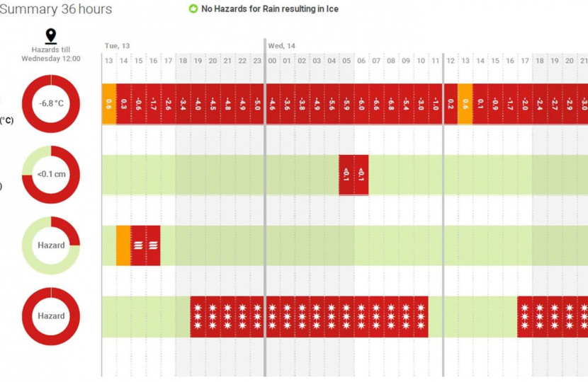
Road Surface Temperatures falling below zero. See table above for details.
2 to 5 day forecast
Thursday will be a mainly dry but very cold day with clear skies. More sunshine expected after freezing fog clears, and sharp frosts overnight. Similar conditions on Friday with light patches of cloud, but long periods of sunshine possible. Saturday will start with variable cloud, but it will gradually dissipate later as winds increase. Less cold than earlier in the week.
6 to 10 day forecast
On Sunday, a deep low-pressure system will approach the UK from the west, bringing a chance of widespread heavy rain and strong winds. Precipitation may start as snow on its leading edge as the frontal system bumps into the cold air, but the extent and duration of this scenario is still uncertain at this point. Monday would continue to see wet conditions for most, but trending warmer. Tuesday and Wednesday are expected to see a scattering of showers as the ow become more northerly whereas, on Thursday, high pressure seems to take control over the weather.
Temperatures are expected to start below average for the time of year on Sunday, becoming milder than usual on Monday and trending around the seasonal average the remainder of the week.
Turning to the gritting operations
Road gritting
The gritting teams had treating the primary and secondary routes this morning as planned and stood down, except for 3No gritters who have been supporting the waste collection teams focusing on icy roads which are impacting the waste collection process. These gritters will stand down shortly.
Road surface temperatures have again struggled to rise above freezing during today and sub-zero temperatures and widespread hoar frost are expected with a potential light dusting of snow in the morning with very slight accumulations. Similar to this morning’s operations a shift are being deployed from 0200hrs tomorrow to retreat both primary and secondary routes across the borough to ensure as much as possible is treated in advance of the morning peak and again we will keep some gritters operational to support the waste collection service tomorrow.
We will continue to support any emergency requests from the blue light services, other gritting requests will be held and only responded to once and if resources are available.
Footways
All priority one footways have been treated, the crews moved onto the priority two footway routes but also supporting the waste collection teams to treat areas so waste collections can be undertaken safely, this approach we be adopted again tomorrow.
Our highways contractor has been able to deploy some resource to start to refill grit bins but please bear with the team as it can take some time to get round to all 600 bins dotted around the borough.
Waste Collection & street operations
We managed to deploy a full collection service on Tuesday, but was severely been hampered by the weather and any missed will be picked up through the week and or over the coming weekend. As mentioned above the gritter teams are working closely with the collections teams to minimise the impacts of the severe weather on collections, it is expected disruption on services will continue for the remainder of the week and crews will work over the weekend to catch up on rounds.
Street cleansing services are suspended as the crews are treating footways, this will continue tomorrow, street bins on main routes are being emptied.
Rest assured the teams are working tirelessly in some very difficult and hazardous conditions to ensure the boroughs highways are as safe as possible and to minimise the impacts to our universal frontline services.
Thank you for your understanding.


