Back in June, I reported that getting around Kenley will be easier, safer and healthier under new plans from the ‘Connecting Kenley’ project.
The Kenley Community Advisory Group (KCAG) is a group made up of residents, residents association, friends associations, churches and schools in Kenley, and it organised the Big Splash event on 13th July. The Big Splash was designed to mark the work of the Connected Kenley project to improve the facilities, services and infrastructure in Kenley, and let residents have their say on the next round of improvements. Over 100 residents came along to hear about the plans and give their thoughts on enhancing pedestrian safety on some of our roads.
After the summer break, the KCAG met to discuss the next steps on the road safety aspect of the project.
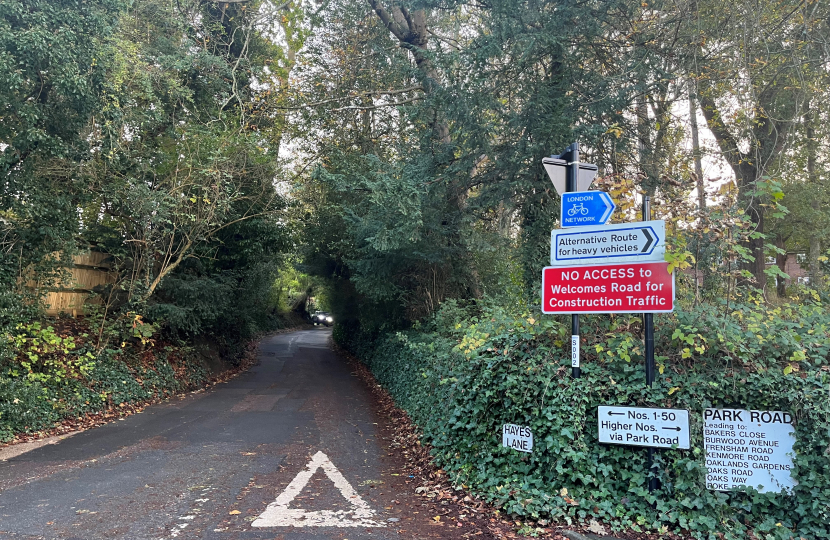
Over the last few years transport / traffic studies have been carried out to assess the impact of developments in the area around potential traffic increases and road safety. Integral to these studies is Hayes Lane South from its junction with Park Road from the station end to its junction with Park Road at the top of the hill. This route is currently used by non – residential traffic and in doing so creates road safety problems for pedestrians, including:
- the winding nature of the road creates visibility issues, drivers are not able to see pedestrians until the last minute and this poses a risk to pedestrians walking uphill and downhill.
- there are no footways along this section of Hayes Lane and pedestrians have no choice but to walk on the road uphill and downhill. Drivers heading south increases speed to overcome the change in topography ; i.e going uphill. Conversely, those drivers heading north use the downhill gradient to pick up speed. Both create road safety concerns for pedestrians and increases the risk of pedestrian / vehicle conflict.
Under the direction of the KCAG, the council will undertake new surveys to identify the volume of traffic using this section of Hayes Lane, as well as traffic surveys in the surrounding streets to appreciate the distribution of traffic across the neighbouring road network.
These surveys, which will take place before the Christmas holidays, will be in the form of rubber tubes placed across the road (generally where lamp columns exists ) over a 24 hour period for 7 days. In addition to counting the volume of traffic across the 24 hour period it can also assess speeds, mix of traffic i.e the amount of light goods and heavy goods traffic using the roads. You can see the location of the tubes in the document below.
The information will assist in understanding any impact across the surrounding road network and will help in developing road safety options for the community to consider.
Carrying out surveys is the first stage of the process and the data will be discussed at the next KCAG meeting in attendance. The group is happy to share the data and we’ll keep you informed on progress. No decisions will be made before Kenley residents have had an opportunity to review and comment on the options.
Additional speed management measures are being considered for Hayes Lane by the aerodrome, including reduction of the existing 40mph speed limit, a crossing point from the airfield to Coulsdon Common and a reconfiguration of the parking.
KENDRA, the Residents Association for Kenley is also actively communicating this progress to residents.


